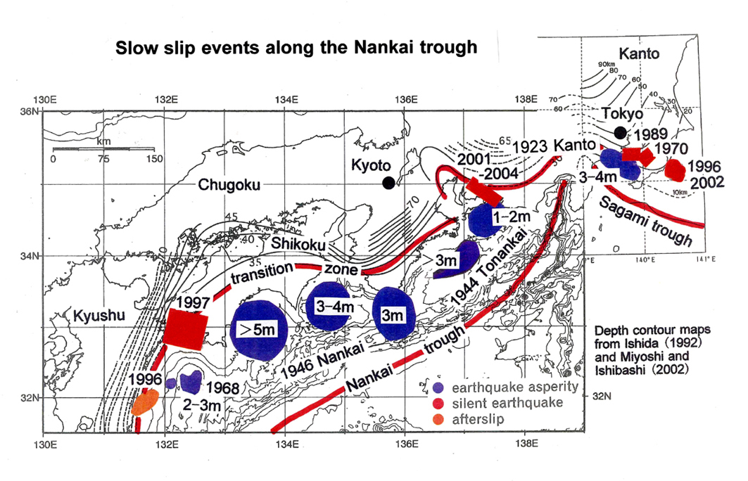
| Figure shows distribution of silent earthquakes (red), afterslip (orange) and major asperities (blue) of Mw8 class interplate earthquakes. Asperities of the 1923
Kanto and the 1944 Tonankai earthquakes were obtained
by seismic waveform inversion by Wald and Somerville (1995) and
Kikuchi et al. (2003),
respectively. Asperities of the 1946 Nankai earthquake
are defined here as the areas which show large slip in all the inversion results
obtained from leveling, tsunami and seismic intensity data by preceding studies.
Figure shows that the slow-slip-events are separated from the major asperities.
The average amount of slip of major asperities of the Mw8 class earthquakes were
around 3-5 m, except for the Off-Atsumi smaller
asperity of slip of 1-2 m. The average amount of slip for the silent earthquakes
were less than 0.2 m, one-order smaller than those of
the major asperities. In other words, the silent earthquakes occurred in the transition
zone between the seismogenic zone and the zone where
stable sliding is dominant. The depth of the transition zone was suggested to be
around 30 km along the Nankai Trough by thermal models
and geodetic inversions. Plate-depth contours are after Miyoshi and Ishibashi (2004) for southwest Japan including the Nankai Trough and Ishida (1992) for the
Kanto district, including the Sagami Trough. Although a number of silent
earthquakes detected are less than 10, we are getting a new view on subduction zone dynamics, which nobody expected 10 years
ago.
See for details Kawasaki, I, Silent earthquakes occurring in a stable-unstable
transition zone and implications for earthquake prediction, Earth,
Planets and Space, 56, 813-821, 2004.
Nature news features by David Cyranoski.
Nature,
1032-1034, 10/28, 2004, A seismic shift in thinking.
References
Ishida, M., Geometry and relative motion of the Philippine Sea plate and Pacific plate beneath the KantoTokai district, Japan, J. Geophys. Res., 97, 489-515, 1992.
Kikuchi, M., M. Nakamura, and K. Yoshikawa, Source rupture process of the 1944 Tonankai earthquake and the 1945 Mikawa earthquake derived
from lowgain seismograms, Earth, Planets and Space, 55, 159-172, 2003.
Kimata, F., K
Hirahara and N. Fujii,
Interplate coupling changes in the Tokai region, Japan, estimated from the vertical movements
by leveling and tide gauge during 1960-2002,
AGU 2002 Fall Meeting, G61-A0978, 2002.
Miyoshi, T. and K. Ishibashi, Geometry of
the seismic Philippine sea slab beneath the region from Ise bay to western Shikoku, southwest Japan, Zisin, 57, 139-152, 2004 in Japanes.
Wald, D., J., and P. G.
Somerville, Variableslip rupture model of the great 1923 Kanto,Japan,Earthquake: geodetic and
bodywaveform analysis, Bull. Seism. Soc. Am.,
85, 159-177, 1995.
|