 |
||
研究テーマの例(Research Topics) |
||
|
Slip and coupling on a plate interface in the subduction zone |
|||
日本列島では,南海トラフや日本海溝から海洋性のプレートが大陸プレートの下に沈み込んでいます,陸側と海側のプレートの境界面の一部は,普段は固着していてひずみを蓄積しており,そのひずみが限界に近づくと,固着していた部分が剥がれて,急激なずれをおこします.このずれが海溝型地震です.GNSS(GPS)等によって観測される地殻変動データを解析することにより,今現在,プレートのどの部分が固着しているか,地震の際にはプレートのどの部分がずれたのかを推定することができます.また,最近では,スロースリップ(ゆっくり地震)と呼ばれるプレートの境界がゆっくりとずれる現象が,いろいろな場所で起こっていて,蓄積されたひずみの一部を解消していることもわかってきました.南海トラフでは,このようなゆっくり地震が四国や紀伊半島の直下で年に数回発生しています.これらの固着と滑りの解析を通じて,プレート境界におけるすべりの収支や場所によるすべりの特性,海溝型巨大地震との関係などを研究しています. キーワード:プレート間カップリング,海溝型地震,ゆっくり地震,スロースリップ,余効すべり |
||||
In and around the Japanses Islands, oceanic plates are subducting beneath continental plates along the Nankai Trough and the Japan Trench. A part of a plate interface between continental and oceanic plates is usually locked and accumulates strain. It suddenly slips when shear strain exceeds the frictional strength on the interface, which is called a megathrust earthquake. Analyses of crustal deformation observed by GNSS(GPS) and other instruments estimate which part of the plate interface is locked or slipped during an earthquak. Recent studies suggest slow slip events or slow earthquakes occur on a various part of the plate interface and release a part of the accumulated strain. Along the Nankai trough, the slow slip events occur beneath Shikoku and Kii Peninsula several times per year. I study a slip budget, regional slip behaviors, large megathrust earthquakes on the plate interface thorugh the analysis of slip and coupling using geodetic data. Keywords: Interplate coupling, Megathrust earthquake, Slow earthquake, Slow slip event (SSE), Afterslip |
||||
 |
 |
|||||
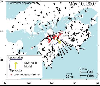
図2 2007年5月10日頃に四国中部で発生した短期的スロースリップイベント(SSE).南海トラフ沿いのプレート境界では,固着領域の下限付近でこのようなSSEが年に数回以上発生しています.Nishimura et al.(2013)の解析より. Figure 2 A slow slip event (SSE) in central Shikoku around May 10, 2007. SSEs on the plate interface along the Nankai Trough ooccur several times per year. After Nishimura et al.(2013). |
||||||
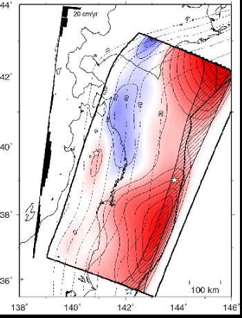
図1 1997年10月〜1999年10月のGNSSデータから推定された東北日本に沈み込む太平洋プレートの境界面での固着分布(西村,2012を修正).赤色はプレート運動速度より滑り速度が遅く固着している領域,青色は,プレート運動速度よりすべり速度が早くひずみを解放している領域を表す.プレートの等値線間隔は2cm/年. Figure 1 Distribution of inetrplate coupling in northeastern Japan from October 1997 to October 1999 (modified from Nishimura (2012)), estimated using GNSS data. Red and blue regions represent back-slip and forward slip, respectively. Back-slip is slip-deficit relative to rigid interplate motion. The contour interval is 2cm/yr. |
||
|
Mechanism for deformation in a strain concentration zone and occurence of inland earthquakes Postseismic deformation following large earthquakes Volcanic deformation and sources Interaction of earthquakes and volcanic sources Regional tectonics using GNSS data |
|||